
Soil Management Guide
Soils Information for Planning Purposes
B. The Environmental Farm Plan
C. Integrated Watershed Management Planning
Introduction
Soils information can be used for a variety of planning purposes including land use planning, environmental farm planning and watershed management planning. All of these planning processes attract a range of stakeholders that are interested in the activities that take place in their communities. Often there are a number of land uses, including agriculture, industry, residential areas and recreation that compete for a limited land base. In Manitoba, land use planning is principally a local process, where local people and their representatives make decisions about allocating land, providing appropriate services, promoting a good quality of life for residents, ensuring orderly development and the prudent use of natural resources. To ensure that development occurs in ways that are compatible with the environment and adjacent land uses, municipal development plans and by-laws are often developed. The intent of these is to designate and protect land for certain purposes in order to promote development, avoid land use conflicts, protect property values, provide efficient servicing, promote healthy and safe living environment and protect natural resources. The Environmental Farm Plan (EFP) is a voluntary process in Manitoba that producers can participate in to assess environmental risks and benefits associated with their land base and management practices. The first step of the EFP is to evaluate the farm’s land assets and to identify any sensitive areas within the land base. Once these areas are identified, any risks to the environment associated with their management, is determined. Finally, an action plan is developed that addresses the environmental risks in a manner that makes a field or the whole farm more productive and cost-efficient. Watershed management planning is also gaining popularity in Manitoba. A watershed management plan is the prescribed use of a watershed in accordance with predetermined objectives. A watershed is an area of land that sheds water to a common point or the area of land drained by a given watercourse. It does not follow political boundaries and can include multiple municipalities and cross international borders. Therefore, watershed management planning often has the extra challenge of involving multiple agencies having responsibility for various activities in the watershed. Normally, all stakeholders located within the watershed are invited to participate in their watershed management plan.
A. Land Use Planning
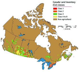
The ultimate authority to regulate land use in Manitoba is vested with municipalities. In accordance with The Planning Act, municipalities may enact development plans and zoning by-laws to plan for and regulate land use and the location and operation of developments. The Provincial Land Use Policies are adopted as a Regulation (184/94) under The Planning Act and outline the broader provincial and public interests in land use and are used as a guide for municipalities when creating their land use plans. The Provincial Land Use Policies Regulation encompasses development policies in nine broad policy areas (including agriculture). Manitoba Agriculture is just one stakeholder in land use planning. From a provincial standpoint, there is a need to protect our food production potential and the role of agriculture in the local, provincial and national economy. Agriculture depends upon productive soil and therefore, it makes long-term economic and environmental sense for land use plans to encourage the protection of both prime agricultural lands and viable lower class lands that are used for agriculture and the conservation of soil. In order to do this, reliable detailed soil survey information is used in order to determine the agricultural capability of the soil in an area. Prime agricultural lands are defined as land composed of mineral soil to be of dryland agricultural capability Class 1, 2 or 3 and includes a land unit of one quarter section or more, or a river lot, 60% or more of which is comprised of land of dryland agricultural capability Class 1, 2 or 3. The province and local governments have recognized that prime agricultural lands need to be protected for food production, agricultural diversification, and value-added opportunities by minimizing the subdivision and wasteful use of this land and protecting farms from encroachment and disturbance by other land uses which may be incompatible with normal farming operations.
Dependable Agricultural Land
 |
Source: Environment Canada 1982, Lands Directorate, CGIS Database Statistics Canada 1999, Environment Accounts and Statistics Division, Environmental Information System (EIS) Database |
“Comprehensive regional planning with soils maps is essential to allocate soil resources for the future. Urban sprawl not only occupies the best soils, but also creates pressures on other soils that have severe limitations. Thus…comprehensive community planning, with detailed soils maps of large areas, will help to prevent some of the land abuse of the past. The future must be given higher priority than it has been given in the past, if peace, progress and prosperity is to be achieved."
(Olson, 1984, p.140)
B. The Environmental Farm Plan
As agricultural producers strive to increase efficiency on their farms, there is also mounting pressure on producers to ensure the environment is being protected. In any given farm operation, “sensitive areas” may exist that present an increased risk to surface or groundwater through leaching, runoff and/or erosion. These areas often also provide inconsistent or continuously poor yields and lower economic returns. Therefore, it makes both environmental and agronomic sense that they should be managed differently from the more productive areas of the farm. Producers that complete an Environmental Farm Plan (EFP) do a self-assessment of their farm in order to identify sensitive areas and natural risks. They use this assessment to prepare an action plan to address those risks. The identification of sensitive areas and natural risks provides the farm managers (whether it is the producer, landowner, agronomist or custom applicator) with additional information that they can use to voluntarily adjust their management practices in a manner that makes economic sense and minimizes any impacts on the quality of soil, water, air or biodiversity. The EFP process demonstrates how the agriculture industry is finding solutions to managing environmental risks without the onus of regulation. Section A of the EFP uses aerial photographs, published soils information as well as the producer’s knowledge of the land to identify the sensitive areas on the farm. Once identified, sensitive areas can be managed separately to improve their productivity and minimize any impacts on water quality. Soil sampling and crop scouting these areas separately from the rest of the field prevents biasing composite sampling procedures meant to represent the majority or “average” portions of the field, and allows for the determination of the yield-limiting factors in the sensitive areas and their appropriate management. By combining various sources of information (such as aerial photographs, cropping history, yield records, yield maps and soils maps) with the producers’ experience and agronomic knowledge, the EFP makes it possible for producers to conduct a thorough assessment of the type, location, extent and severity of limitations on their farms.
Recommendations
- Evaluate your farmstead for the potential risks of runoff and leaching.
- Examine aerial photos of your fields and identify any sensitive areas.
- Use the agriculture capability table (Table 2.2) and your experience to assess the type and severity of the limitations in each field.
- Based on what you know about your fields, consult soil survey reports to confirm or re-assess your lands.
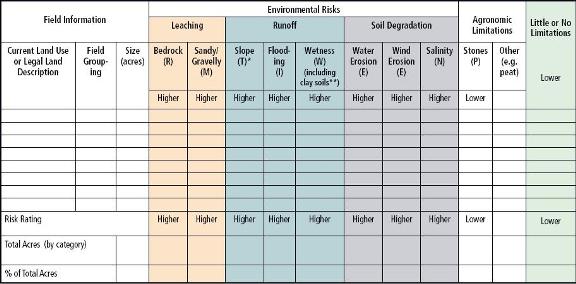
- Fill out the summary chart (Table 10.1) to record field information for your farm. Keep this information available as you complete the other worksheets.
- Use this information to help you choose agronomic practices that will decrease the potential for environmental degradation.
- Consult the appropriate agricultural extension specialist for additional information and support.
Table 10.1 Compilation of field assessments and risks using agriculture capability codes
| Lower Risk (1) = No risks or only stoniness (P) identified. Stoniness is an agronomic limitation but presents little or no risk to the environment. Higher Risk (4) = Some risks identified - R (bedrock), M (sand or gravel), T (slope), I (flooding), W (wetness including clayey soils with improved drainage), N (salinity) or E (erosion) | |
 |
Click on table for printable version |
| * Sloping lands increase the risk to the environment from runoff. The exception to this is sandy/gravelly soils because water can infiltrate these soils before runoff occurs. ** Heavy clay soils with improved surface drainage present a risk to the environment from runoff. Although some of these soils are our most productive agricultural soils, they would be bumped from the green (little or no limitations) column to the blue (runoff risk). *** Should there be more than one risk factor on the same acreage, it should be noted (i.e. slope and stones). Therefore, total acres may not equal farmer acres. | |
C. Integrated Watershed Management Planning
Community-based watershed management is a process for managing water resources that involves engaging stakeholders in making and implementing management decisions that are sustainable and appropriate for local conditions. In Manitoba, The Water Protection Act specifies the basic content of an integrated watershed management plan including the requirement for consultation with various parties through a local watershed authority. Through this process, agricultural producers are working together with other local stakeholders to develop strategies to protect and enhance the quality of water within their watershed with positive impacts downstream. Local knowledge, combined with technical information from provincial and federal government departments and other agencies, is considered throughout the planning process. Information related to the study area is first compiled into a state of the watershed report (a resource inventory). It often includes soils information such as soil texture, agriculture capability and areas prone to wind and water erosion. This inventory is then used to identify areas where improvements could be made through a change in management practices. Community consultations occur at various times during the planning process in several communities throughout the watershed. At these meetings, additional information is sought from the public on watershed resource issues and on the proposed watershed management plan. The integrated watershed management plan addresses how implementation will occur and provides a mechanism to measure future progress on meeting resource goals and objectives. The plan allows the watershed authority to set programming agendas and direct annual funding to watershed priorities. The watershed management plan must also be considered in the municipal development plan in order to avoid potential conflicts with existing or future development in the watershed. An integrated watershed management plan helps to ensure that the resources in the watershed are managed in a sustainable manner. The input and support of local stakeholders results in solutions that are customized to the area and are therefore more likely to be implemented because of the community support received.
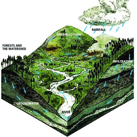 Figure 10.1 Example of a watershed |