Targeted Geoscience Initiative II
(TGI II)
Saskatchewan Ministry of the Economy,
Manitoba Mineral Resources, Geological Survey of
Canada, University of Alberta and University of Saskatchewan
Regional geoscience knowledge is an essential
component in deciphering large-scale basin processes that lead
toward effective hydrocarbon- and mineral-exploration strategies.
The stratigraphic framework and hydrocarbon potential of the
Williston Basin has been re-examined in eastern Saskatchewan and western
Manitoba as part of the Williston Basin Architecture and Hydrocarbon
Potential Project. This is a collaborative program involving
Saskatchewan Ministry of the Economy, Manitoba Mineral Resources, Natural Resources Canada and academia.
The primary objective of this Targeted Geoscience Initiative (TGI)
was to develop an integrated geoscience dataset incorporating new
stratigraphic data, seismic, gravity and aeromagnetic information,
hydrogeological mapping, and remotely sensed data over a large area
encompassing the Phanerozoic succession of the northeastern
Williston Basin. Exploration for prospective hydrocarbon reservoirs
and mineral resources in the Williston Basin is usually led by small
Canadian companies, which rely on government and universities for
development of advanced modeling techniques of basins. These large
regional syntheses provide a consistent framework to develop new
exploration ideas in a mature basin. Enhanced knowledge of the
distribution of subsurface minerals (e.g. brines and potash),
hydrocarbon migration pathways and entrapment mechanisms within and
beyond traditional geographic areas of hydrocarbon production have
been realized from this regional and integrated approach. A seamless
3-D geological model of Paleozoic- and Mesozoic-aged rocks from
subsurface to outcrop in eastern Saskatchewan and Manitoba on which
to base further, and more detailed, geological investigations has
been completed, and can be viewed by clicking on the '3D Model' link
to the left.
All maps produced from this project are
available for free download in the Maps section. Along with the
maps, the website displays the project bibliography for the
Williston Basin, regional cross sections, abstracts, papers from
conferences, final geophysical report and maps, virtual field trips,
and geological tops database.
It is suggested that the user visit the site
regularly to view new updates.
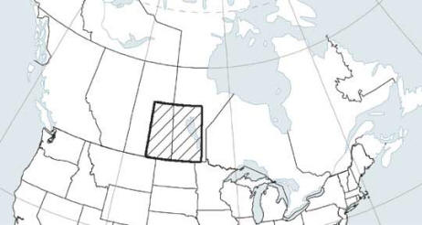
TGI study area
|
|
TGI II
Williston Basin Project
Working Group


|
|