| HOME | KIDSROCK | TEENSROCK | GEOTOURS |

| History of Rock |
Exploration and Mining |
Directions | Opportunity Rocks! |
GeoTours | Legends of Rock |
Geology FAQs |
More to X-plore! |
Geo-Links | Explore Manitoba |

For geologist Jim Bamburak, the prairies rock
Bamburak and his colleague Mark Pacey have shot a series of videos to help people to learn about the geology of Manitoba.
October 2015
by Kevin Miller, Canadian Mining & Energy magazine
For many people making a road trip across Canada, the Prairie Provinces are something to endure rather than enjoy. With nothing but flat land for as far as the eye can see, most people can't wait to get to the mountains in the west or the Canadian Shield in the east. But for Jim Bamburak, senior industrial minerals geologist for the Manitoba Geological Survey, a trip across the prairies couldn't be more fascinating—or more relevant. What interests Bamburak isn't so much what you can see on the surface. The truly enthralling aspect of the prairies is what lurks right below your feet. "The prairies aren't boring at all," Bamburak said. "Three-dimensionally, in the subsurface, there are a lot of fascinating things happening." Spend enough time with Bamburak and he'll explain how the entire prairie region is like a gigantic plumbing system, with rainfall falling on the Rockies, running deep below the earth, and then rising again and flowing out of saltwater springs at Lake Winnipegosis. Speaking of water, he'll also point out how the edge of one of the continents that merged to form North America cuts right through western Manitoba, which means if you were standing there two to four billion years ago and looking west toward Saskatchewan and Alberta, you would have seen nothing but ocean. "There's a major crustal suture in the pre-Cambrian rock down below, which I can visualize from maps I've seen. It's an extension of the Thompson nickel belt. Everything west of that was the Pacific Ocean of that day." Bamburak also points out how the further west you go, the younger the bedrock "at surface" becomes. This contrasts with a Precambrian basement that is exposed in eastern Manitoba; is buried as deep as a mile and a half in southwestern Manitoba, and is more than 3 miles deep at the foot of the Rockies. |
|

"There's such a wealth of geological time in Manitoba," he said. "In fact, the geology across the prairies is fascinating if you stop to look at all of the steps that are occurring both above and below ground."
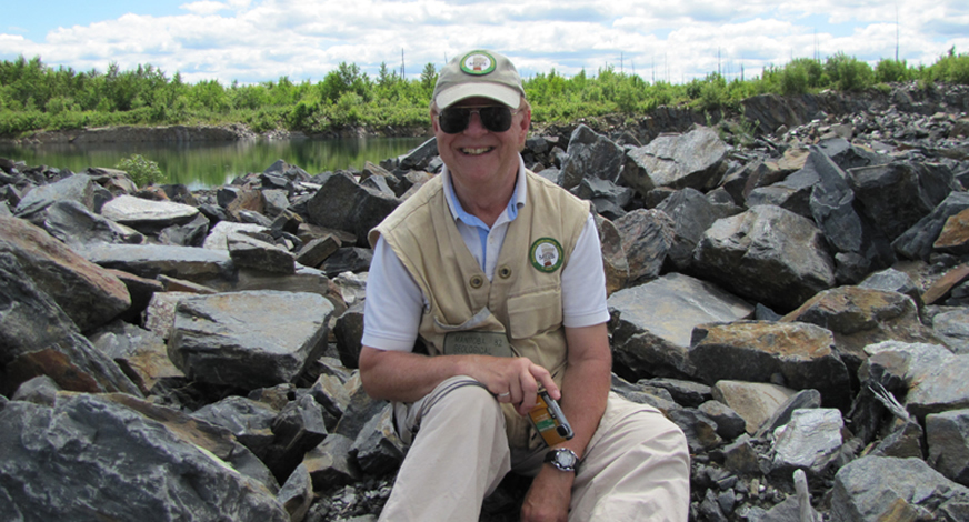
A ROCK STAR: Sitting on a pre-Cambrian phyllite outcrop, Jim Bamburak is nearing the end of his career and is encouraging budding geologists.
In an effort to get those who are tempted to speed through the prairies to slow down and take a closer look, Bamburak and his colleague Mark Pacey have shot a series of roadside geology videos that allow people to learn about the geology of Manitoba without even having to get out of their car. While Bamburak and Pacey use the videos to point out various types of rock formations and outcroppings motorists might spot on their travels, they also show how various rocks have been used for practical purposes, such as the Boissevain sandstone blocks that were used to construct the Methodist church in Boissevain, Manitoba.
This is in keeping with Bamburak's desire to help people understand that geology isn't just a source of interesting trivia; it's immensely practical.
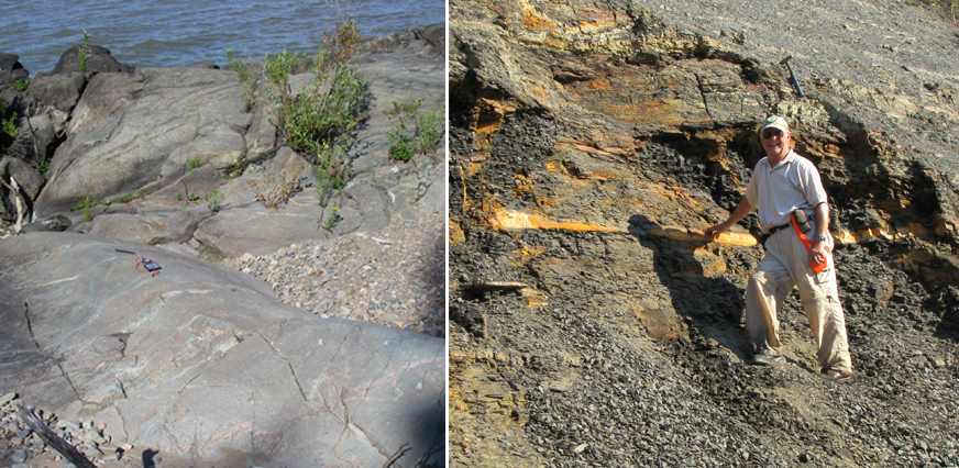
IN THE FIELD: (L) Located on the east shoreline of the south basin of Lake Winnipeg are outcroppings showing Archean tonalite with veins and dykes of biotite granodiorite to granite. (R) Jim Bamburak stands by a non-calcareous, oxidized, silty black shale along the Vermillion River, southwest of Dauphin, Manitoba.
"All of the things you see around you in your houses and buildings, most of it comes from the ground somewhere," he said. "To make cement, you need limestone, and without cement, you have no roads, no foundations. People have gyprock panels in their homes. That came out of a gypsum mine. Body parts, replacements for bones, titanium, even eyeglasses. Just about everything around you comes from geology."
Bamburak's own interest in geology began when his family took him for wiener roasts in gravel pits around the Winnipeg area.
"I developed a fascination for picking up rocks," he said. "I didn't know what they were, because I had no one to explain them to me. It wasn't until university that I became familiar with them. It was a very early interest, and that's what I am, a geologist, and I guess I always will be."
As he nears the end of his career, Bamburak is passionate about encouraging other budding geologists like himself to become "rock stars" when they grow up.
In addition to the roadside geology videos and lectures in schools, another way he's doing that is through participating in the Manitoba Geological Survey's "Manitoba Rocks!" mineral education program. It features an extensive website for children and teens that covers everything from geology and the geo-history of the province to information on mining and oil and gas development.
Most recently, the program has developed the Dig It! card game, which offers children a fun opportunity to learn about Manitoba's geology.
"It's the kind of thing we're all doing to promote an interest in geology for the next generation."
Here's the YouTube link to Bamburak's roadside geology videos.