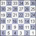
Section-Township-Range Numbers
Section numbers are 1-square mile plots of land as defined by the Dominion Land Survey in the 1800's. When western Canada was first surveyed, it was divided into six mile by six mile blocks called townships. The location of each township is described as being east or west of the Principal Meridian. This is a true north-south line near Winnipeg, chosen in 1869, at what was considered to be the western limit of settlement
- Quarter Section e.g. SW
Each section is divided up into 4 quarters: the Northwest (NW), Northeast (NE), Southeast (SE), and Southwest (SW) quarter. These two letters are the first piece of information in a section-township-range designation. - Section e.g. 9

A section is a piece of land one mile by one mile square. A group of 36 sections, which takes up a square piece of land 6 miles by 6 miles in size, makes up one township. The 36 sections in each township are numbered in a specific order. The first section is at the southeast corner, and the second lies directly to it's west. The rest of the sections snake their way north, ending with section number 36 at the northeast corner. - Township e.g. 8
One township is 36 sections, as described above, but the word is also used to describe where this township is located. The township number describes how far north of the U.S. border this township lies. The southern most township in Manitoba has a township number of 1. The township to the north of that one, which lies from 6 miles to 12 miles north of the U.S. border, has a township number of 2. - Range e.g. 6E
The range describes how far east or west a township lies. This part of the section-township-range designation is composed of a number followed by an 'E' or 'W', which shows if this township is East or West of the Principal Meridian. For example, Morris and Headingley lie in range 1E. The townships to the east of those lie in range 2E, 3E, 4E, etc. Lowe Farm, Brunkild and St. Francois Xavier lie in range 1W. The townships to the west of those lie in range 2W... etc.