
Manitoba Heritage Council Commemorative Plaques
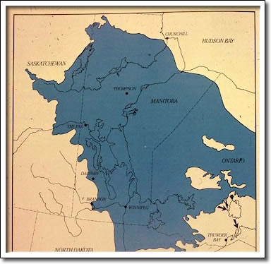
Glacial Lake Agassiz
Birch River Wayside Park
PTH 10
Glacial Lake Agassiz was formed 11,500 years ago from the meltwaters of a massive ice sheet that had previously covered all of Manitoba. At its maximum, the lake was larger than any other on the continent, covering in total more than 500,000 square kilometres of Manitoba, Saskatchewan, Ontario, North Dakota and Minnesota. During its 4,500-year history, Lake Agassiz rose and fell several times with advances and retreats of the glacier and the opening and closing of various drainage channels. Whenever the lake stabilized for a time, waves created low cliffs and beach ridges which are still visible.
The beaches figured prominently in the lives of Manitoba’s Aboriginal peoples. Elevated and well-drained, these platforms served as campsites, lookouts for sighting game, burial grounds, travel routes between seasonal camps, and sources of stone to fashion tools. Glacial Lake Agassiz played a central role in shaping Manitoba’s topography and human history.