
Shellmouth Dam and Reservoir
Background and Description
Following the disastrous Winnipeg flood of 1950, an investigation of alternatives for protecting Winnipeg from large floods was undertaken by the federal Department of Resources and Development; it was titled the Report on Investigations into Measures for the Reduction of the Flood Hazard in the Greater Winnipeg Area. It was followed by the Royal Commission on Flood Cost Benefit to determine the economic benefits of the major works proposed in the Basin Investigation. The Royal Commission report recommended a system of water control infrastructure to protect the City of Winnipeg and several other locations from future flood events. Specifically, the report recommended the Red River Floodway, the Portage Diversion, and a Dam and Reservoir on the upper Assiniboine River near Russell. Later, further studies determined that the Shellmouth area was a more suitable location for the Dam and Reservoir.
The Shellmouth Dam was constructed in a deep, wide portion of the Assiniboine Valley located approximately 5 km (3 miles) upstream from the community of Shellmouth, or 24 km (15 miles) northwest of Russell. The reservoir created by the dam is known as the Lake of the Prairies and is approximately 56 km (35 miles) in length.
Construction of the dam began in 1964, and the dam came into full operation including filling of the reservoir in the summer of 1971. Construction was completed in 1972 at a cost of $10.8 million. Operation of the dam was initially the responsibility of the Prairie Farm Rehabilitation Administration (PFRA), but ownership of the dam and operational responsibility were transferred to the Province of Manitoba in 1975.
The dam was designed as a multi-purpose reservoir, to provide flood damage reduction to Winnipeg and other communities along the Assiniboine River, as well as a more reliable water supply for downstream users. Since construction of the dam, additional operation objectives have emerged, such as flood protection of downstream agricultural lands, ecosystem health requirements on both the river and the reservoir, and recreational interests on the Shellmouth Reservoir.
 looking upstream. Upper right is the Shell River. The outlet is on the right hand side of the photo and the spillway is on the left hand side of the photo.")
An aerial view of Shellmouth Dam and Reservoir (Lake of the Prairies) looking upstream.
Upper right is the Shell River. The outlet is on the right hand side of the photo and the spillway is on the left hand side of the photo.
The dam is approximately 21.3 metres (70 feet) high and has a crest length (also known simply as “length”) of 1,270 metres (4,166 feet). The facility includes a 4.6 metres (15 feet) diameter reinforced concrete conduit for releasing flow from the reservoir; this is often referred to as the “outlet”. It also includes an un-gated concrete chute spillway designed to spill water when reservoir levels are high. The reservoir is capable of storing approximately 477,365 dam3 (387,000 acre feet) of water at the spillway crest elevation of 429.31 metres (1,408.5 feet). (A dam3 is equal to 1,000 cubic metres.)
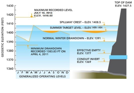
Generalized Shellmouth Dam operating levels
The dam operates by storing runoff water that flows into the reservoir from the watershed upstream of the dam, then releasing flows through the dam’s conduit outlet. Thus the dam can provide a flood reduction benefit during periods of high flow such as during spring runoff periods. The water stored by the dam can also be released during drier periods to help augment low flows on the Assiniboine river downstream, where the water supply is used for irrigation, industrial, municipal and domestic purposes. During periods of low flow, stored water may also be released to help maintain flows on the river to support a healthy aquatic ecosystem.
The operation of the Shellmouth Dam and Reservoir can be complex due to a relatively small reservoir storage capacity, the need to balance multiple objectives, which are sometimes at odds, and the uncertainty associated with forecasting inflows and downstream tributary flows. Manitoba Infrastructure operates the structure in accordance with operating guidelines that attempt to balance the various interests and in consultation with the Shellmouth Reservoir Regulation Liaison Committee. Operation decisions are informed by applied knowledge of past and present weather and flood events, forecasted weather conditions, hydrologic conditions in the basin, upstream and downstream tributary flow conditions, and hydrologic models.
Operating Guidelines
Guidelines for Spring
- Target a reservoir level of 1402-1404 feet after spring runoff is complete.
- Outflows must meet downstream requirements. Minimum outflow will be 25 cfs to support fish downstream of reservoir.
- Keep outflow below 500 cfs if possible until Assiniboine crest has passed Miniota. All operations will try to prevent or minimize downstream flooding unless this poses a high risk of flooding later during the seeding or growing season.
- Outflows not to exceed 1200 cfs if forecast based on observed rain and streamflow and an outflow of 1200 cfs indicates a peak reservoir level below 1405 feet.
- Outflow not to exceed the downstream bankfull capacity of 1600 cfs if forecast based on observed rain and streamflow and an outflow of 1600 cfs indicates a peak reservoir level below 1407 ft.
- If forecast based on observed rain and streamflow indicates that reservoir level will overtop spillway with 1600 cfs outflow, set April outflow as high as required to keep level below 1407 feet. This will maintain 1.5 feet of storage capacity below the spillway to prevent overtopping due to additional rainstorms.
- During May or June, if valley crops have been seeded, allow overtopping of spillway to save crops and use peak shaving if necessary to prevent total outflows from exceeding 2000 cfs. Peak shaving involves reducing conduit outflows to maintain a maximum total outflow when spillway is overtopped. Flooding at 2000 cfs is confined to low lying areas such as old oxbows.
Guidelines for Summer
- Target range for summer and autumn is 1400-1404 feet.
- Operate to meet downstream needs such as licensed municipal and private uses, irrigation needs, minimum flows for fish and sewage dilution. Minimum needs are 100 cfs at Brandon and 200 cfs at Headingley.
- Minimum outflow of 50 cfs and maximum of 500 cfs while reservoir in target range.
- Increase outflows up to 1000 cfs if necessary to prevent reservoir level from exceeding 1405 feet.
- If a serious flood develops during the growing season, adjust outflows up to 1600 cfs if necessary to prevent overtopping of spillway. If spillway is overtopped anyway, use peak shaving to minimize the peak outflow while reservoir is below 1410.6 feet.
- If reservoir level in excess of 1410.6 feet is inevitable with a 2000 cfs total outflow, increase conduit outflows as required to prevent level from exceeding 1410.6 if possible.
- On falling limb after spillway overtopped, operate to maintain 1400 cfs until reservoir down to 1407 feet and 1000 cfs until reservoir down to 1405 feet.
- Operate to prevent decline of more than 0.4 feet per day at bridge downstream of Shellmouth.
- When summer reservoir declines below 1400 feet, set outflow to minimum of 25 cfs if this is sufficient to meet downstream needs.
- During severe drought, meet downstream requirements to a level of 1390 feet. At lower levels, outflows to be approved at ministerial level under The Water Protection Act.
Guidelines for Autumn
- Operating guidelines and target levels and flows would be very similar to those for the summer period, with the following exception:
- If a flood situation develops after harvest in the valley has been completed, outflows would be kept below 1600 cfs if possible, but peak shaving would not be employed to prevent higher flows due to possible overtopping of the spillway.
- “Autumn” refers to the months of September and October
Guidelines for Winter
- Winter outflows shall meet downstream requirements with a minimum of 100 cfs to prevent the river from freezing to bottom with resultant ice buildups.
- Avoid large fluctuations in winter outflow if possible.
- Minimum winter drawdown level to range from 1386 to 1400 feet depending on predicted spring runoff volume. Drawdown to be such that target reservoir level is reached after spring runoff. (Fisheries Branch indicates that at winter levels below 1386 fish kill is a concern)
- Be in a position to draw down to 1386 by the end of March without exceeding 1500 cfs outflow, whenever upper decile forecast indicates a spring level near spillway.
- November and December outflows based on lower decile inflow forecast.
- January and February outflows based on lower quartile inflow forecast.
- March outflow to be based on median inflow forecast. However, release up to 1500 cfs in March to draw reservoir down to 1386 if spillway is overtopped at lower outflows with upper decile inflow forecast.
Operational Information
Shellmouth Reservoir Regulation Liaison CommitteeFollowing a large flood event in 1996, the Shellmouth Reservoir Regulation Liaison Committee was created in order to facilitate communication between the department and stakeholders about operation of Shellmouth Dam. Regular meetings of the committee are held throughout the year, but more frequently prior to and during flood events.
There is a broad range of stakeholders represented on the committee. Stakeholder representatives on the committee provide information about local conditions, feedback and recommendations on operation of the dam, and also serve to communicate dam operations to their respective stakeholder communities. Membership is based on major interest groups along the river with consideration for regional representation. Membership is as follows:
- Assiniboine Valley Producers Association (Shellmouth to St. Lazare)
- Assiniboine Valley Producers Association (St. Lazare to Brandon)
- Association of Irrigators of Manitoba
- Rural Municipality of Russell-Binscarth
- Rural Municipality of Riding Mountain West
- Rural Municipality of Hillsburg-Roblin-Shell River
- Shellmouth Assiniboine Valley Economic Development
- Lake of The Prairies Conservation District
- Upper Assiniboine Conservation District
- Little Saskatchewan River Conservation District
- Assiniboine Hills Conservation District
- La Salle-Redboine Conservation District
- Manitoba Infrastructure (Chair)
- Manitoba Agriculture
- City of Winnipeg
- City of Brandon
Links to real-time data (Water Survey of Canada real-time gauges)
- Lake of the Prairies near Shellmouth
- Shell River near Inglis
- Stony Creek near Kamsack
- Assiniboine River at Kamsack
- Whitesand River near Canora
- Souris River at Wawanesa
- Qu’Appelle River near Welby
Reports and Studies
- Report on 2014 Artificial Flooding due to Operation of the Shellmouth Dam (July 7, 2015) (PDF, 3.6 MB)
- 2011 Shellmouth Artificial Flood Report (PDF, 4.76 MB)
- 2012 Shellmouth Artificial Flood Report (PDF, 2.31 MB)