Fairford River Water Control Structure
Background and Description
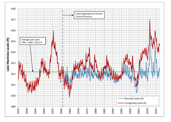
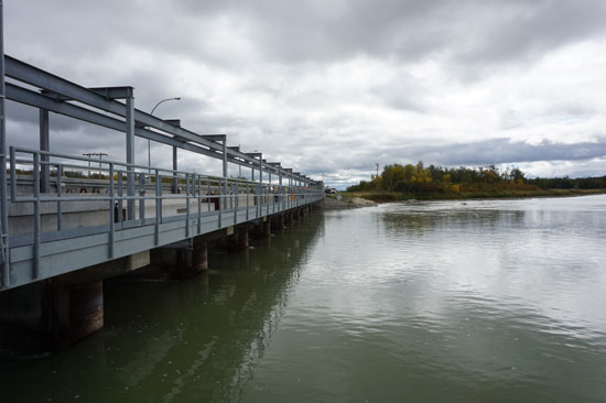
The Fairford River Water Control Structure is an outlet located on the Fairford River between Lake Manitoba and Lake St. Martin. It serves to regulate water levels on Lake Manitoba. Construction of the FRWCS began in 1959, with the structure becoming operational in 1961.
The Fairford River Water Control Structure consists of:
- An excavated channel - used to increase the capacity of the Fairford River
- 11 stop log bays - used to adjust the flow rate of the Fairford River
Flow through the Fairford River Water Control Structure is influenced by several factors, including lake level, wind direction, stop log setting, ice conditions and flow conditions.
Fairford River Water Control Structure
Operating Guidelines
Minimal Log Change Model (July 2003 Lake Manitoba Regulation Review Advisory Committee Report (PDF, 2 MB)):
The Manitoba government conducted a series of water level modeling simulations on behalf of the Lake Manitoba Regulation Review Advisory Committee Graphs displaying the results of the Minimal Log Change Model for Lake Manitoba and Lake St. Martin are presented on the following pages.
Under the Minimal Log Change regime, there are no target elevations for water levels on Lake Manitoba or Lake St. Martin. Rather, water levels are generally maintained between 810.5 to 812.5 feet above sea level (ft asl) on Lake Manitoba with the expectation that water levels will occasionally reach 810.0 ft asl or lower in some years, and 813.0 ft asl or higher in other years. Water levels on Lake St. Martin are generally managed between 797.0 and 800.0 ft asl. When both lake levels are within the specified ranges, flow through the Fairford River Water Control Structure (FRWCS) is maintained at 50 per cent of capacity.
If Lake Manitoba is below its range (below 810.5 ft asl), or if Lake St. Martin is above its range (above 800 ft asl), flows through the FRWCS are set to the specified minimum. If Lake Manitoba is above its range (above 812.5 ft asl), or if Lake St. Martin is below its range (below 797.0 ft asl) flows through the FRWCS are increased to restore the lakes to their desired operating ranges.
The minimum outflow through the FRWCS is 800 cubic feet per second, except when Lake Manitoba water levels are too low to produce that amount of outflow.
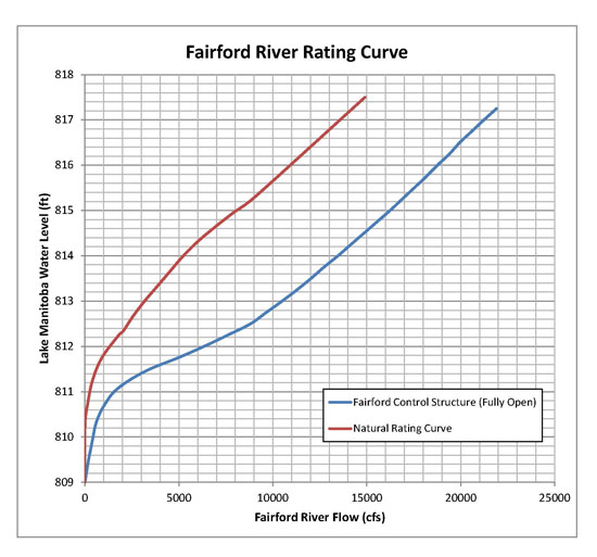
Rating Curve
Operational Information
Links to real-time data (Water Survey of Canada real-time gauges)
- Lake Manitoba at Steep Rock
- Lake Manitoba at Westbourne
- Fairford River near Fairford
- Lake St. Martin near Hilbre
- Dauphin River near Dauphin River
- Waterhen river near Waterhen
- Lake Winnipegosis at Winnipegosis
- Whitemud River at Westbourne
- Portage Diversion near Portage La Prairie
Stop Log Record
The Fairford River Water Control Structure controls the rate of outflow from Lake Manitoba through the addition and removal of stop logs. When the level of Lake Manitoba is low, logs are added to the control structure bays, reducing the size of the openings available for flow, and reducing discharge. When the level of Lake Manitoba is high, logs are removed from the bays, increasing the size of the openings available for flow, and increasing discharge.
The linked table belowcontains the detailed operation of the Fairford River Water Control Structure’s stop logs over the last several years. For each operation, the number of logs added or removed is indicated, along with the resulting number of logs in each bay.
- Stop Log Record (PDF 220 KB)
Lake Manitoba - Natural water levels vs. recorded water levels