
Red River Floodway
Background and Description
One of the most significant flood protection measures in Manitoba is the Red River Floodway, which protects the City of Winnipeg. Starting in 2005, Canada and Manitoba invested $628 million to further expand the Red River Floodway.
- The original floodway was built between 1962 and 1968 and cost $63 million.
- At the time, excavation of the floodway channel was the second largest earth moving project in the world (second only to the Panama Canal and larger than the Suez Canal project).
- Since 1968, it has prevented tens of billions of dollars in flood damage in Winnipeg.
- It is often referred to as Duff’s Ditch in recognition of then-Premier Duff Roblin, who spearheaded the development of the floodway.
- The expansion of the current floodway system (including the West Dike and channel outlet) began after the 1997 flood, to protect the City of Winnipeg from a one-in-700-year flood. It increased the floodway's capacity – from 1700 cubic metres per second (cms) (60,000 cubic feet per second (cms) to 3964 cms (140,000 cfs).
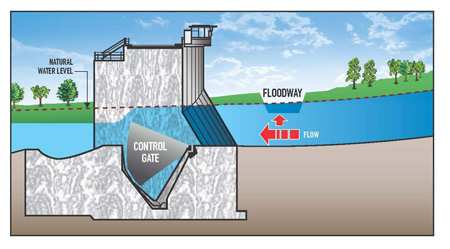
Under low flow conditions the water level in the Red River is below the floodway channel inlet lip. Under these conditions, all of the Red River flow passes through Winnipeg.
 Floodway gates during low flow conditions |
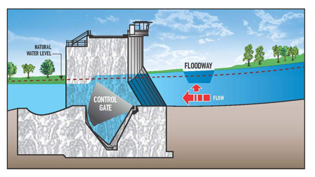
When the water level in the Red River rises just above the top of the floodway channel inlet lip, most of the Red River flow still passes through Winnipeg, but some begins to flow into the floodway channel. This splitting of flows between the floodway channel and the Red River results in a drawdown of water levels upstream of the floodway channel inlet. As a consequence, the water level at the floodway channel inlet drops below the natural level. The natural water level on the Red River at the floodway channel entrance is defined as the water level that would have occurred at this location in the late 1950’s, if the flood control works had not been built. These works include the City of Winnipeg’s primary dikes, the Red River Floodway, the Portage Diversion, Shellmouth Dam and Reservoir and the Assiniboine River dikes. The calculation of natural also accounts for a similar level of development and infrastructure to what was in place at the time when the floodway was designed.
 Floodway gates during high flow conditions |
The operation of the floodway is governed by four operating guidelines. The use of the terms "rules" and "guidelines" is often used interchangeably among different sources. For clarity, Manitoba Infrastructure is moving towards using the term guidelines, as referenced in The Water Resources Administration Act. That change is reflected throughout the following text.
Under Floodway Operation Guideline 1, Normal Operations, the floodway gates are raised so that the water level south of the floodway channel inlet is restored to its natural level. This raising of water levels, in turn, results in more water spilling into the floodway channel and less flow going through Winnipeg. As Red River flows continue to increase, the level south of the floodway channel inlet drops below natural again and the gates are raised further to restore water levels to natural.
In all spring floods except at the peak of the flood of 1997, the floodway has been operated under Guideline 1, to ensure that the water level south of floodway channel inlet is maintained at the natural level – that is, the level that would occur if the flood control works did not exist.
Guideline 1, Normal Operations, was used in the summers of 2005 and 2014 due to exceedingly high summer flows.
|
Under Floodway Operation Guideline 2, Major Flood Operation, the floodway is operated to keep water levels in Winnipeg below the primary dike system, raising water levels upstream of the floodway channel inlet above natural. If forecasts indicate that levels at the floodway inlet will rise more than two feet above natural, the City of Winnipeg must proceed with emergency raising of the primary dikes and temporary protection measures on the sewer systems in accordance with the flood level forecasts within Winnipeg.
Under Floodway Operation Guideline 3, Extreme Flood Operation,the floodway gates are raised so that the water level at the floodway channel inlet is increased to the maximum level that can be held by the floodway west embankment and the West Dike. All additional flows are allowed to pass through Winnipeg.
Floodway Operation Guideline 4, Emergency Operation to Reduce Sewer Backup in Winnipeg, is applied post-spring flood when high water levels affect Winnipeg’s storm sewer and combined sewer systems. The combination of high water levels and a high intensity rain storm can overwhelm the sewer systems causing basement flooding, resulting in damages and risk to health.
If there is potential risk of high river levels concurrent with high intensity rainstorms, the floodway may be operated to lower water levels in Winnipeg by diverting some of the Red River flows into the floodway channel, reducing the damages and potential health risk caused by basement flooding in Winnipeg. This is accomplished by raising the inlet control structure gates, which raises water levels upstream; under this guideline the water level cannot go higher than bank full condition (760 feet at gauging station 05OC026 just upstream of the floodway inlet).
Operation is considered an option if the level at James Avenue is at or above 14 feet. This guideline states that the floodway must not be operated to achieve a river level of less than nine feet at James Avenue.
Emergency operation of the floodway to reduce the risk of sewer backup in Winnipeg has occurred in 2002, 2004, 2005 and 2010.
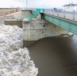
 Floodway gates raised during Guideline 2 operation |
Artificial flooding of some land and roads south of the floodway inlet control structure occurs when water levels out of the floodway channel inlet are raised above natural under Guidelines 2, 3 or 4. In these instances, the Manitoba government provides compensation to individuals who experienced physical damages due to artificial flooding.
Read more about Red River Floodway operations and potential post-spring non-emergency operation of the Red River Floodway:
The floodway is recognized as a National Historic Civil Engineering Site and is considered one of the world’s 16 engineering marvels.
 |
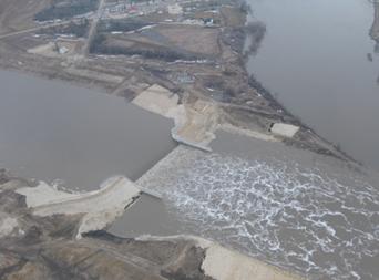 |
| Floodway inlet control structure south of Winnipeg |
Floodway outlet structure in Lockport |
Top 10 Red River Floods since 1800

Floodway Expansion
In 1997, Manitoba experienced a major flood on the Red River. This flood forced the evacuations of communities in the Red River Valley and came close to reaching the floodway's capacity and threatening the protection of Winnipeg. In the end, the Red River Floodway did protect Winnipeg and saved the city from the devastation that was experienced by our American neighbours in Grand Forks, North Dakota.
In the aftermath of the 1997 "Flood of the Century," the International Joint Commission (IJC) reviewed flood protection measures and found that, under flow conditions similar to those experienced in 1997, the risk of failure of Winnipeg's flood protection infrastructure would be high. As a result, the IJC recommended that to ensure public safety, the city, province and Canadian government focus immediate action on designing and implementing measures to improve protection for Winnipeg.
Expanded Floodway Facts:
- The expanded floodway increased the capacity of the Floodway from a 1-in-160 year event to a 1-in-700 flood event. This is larger than the 1997 "Flood of the Century" and the flood of 1826 (highest flood on record).
- The expansion increased the capacity of the channel from 1,700 cubic metres (60,000 cubic feet) of water per second to 4,000 cubic metres (140,000 cubic feet) per second.
- More than 21 million cubic metres of earth was moved to construct the expanded channel.
- Upgrades and improvements to 8 bridge crossings, the outlet and inlet structures, the West Dike, utilities and drainage services were required as part of the expansion project.
- The total cost for the Floodway Expansion project was $628 million.
Flood Simulation Project
Benefits of Floodway Expansion highlighted through Flood Simulation Project
The flood simulation project was designed to demonstrate a 1-in-700 year flood with the original and the expanded floodway. This presentation uses advanced technology to simulate various Red River flood scenarios and helps to inform the public about the benefits of the Red River Floodway Expansion project.
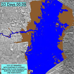
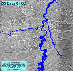
The flood simulations generated by the flood simulation project are shown below. They demonstrate the impact of a 1-in-700 year flood with the original floodway on Winnipeg versus the impact of the same flood with the expanded floodway. The simulation, based on sophisticated computer software, demonstrates that the impact of a flood of this size would result in approximately two-thirds of Winnipeg being impacted by basement and overland flooding. With the expanded floodway, the amount of flooding within Winnipeg would be dramatically reduced to potentially isolated locations along the Red River.
The flood simulator was first unveiled during the Manitoba Clean Environment Commission’s public hearing process in 2005. It was completed with the expertise and technology of the Canadian Hydraulics Centre of the National Research Council.
Click Image Below to View Simulation (WMV File)
 |
 |
|
Impact of sewer and overland flooding on Winnipeg in the event of a 1-in-700 year flood with the original floodway. |
|
Impact of sewer and overland flooding on Winnipeg in the event of a 1-in-700 year flood with an expanded floodway |
Would you like to download this video in another format?
(PC Users right click and "save link/target as"; Mac users control click "download link to Disk")
Floodway Inquiries
For any floodway inquiries please call 204 945-3819.