Smoke Dispersion: the Key to it All
When it comes to understanding the Manitoba Crop Residue Burning Program and daily authorizations, one of the most important things to realize is that the main intent of this program is the control of smoke. On any given day, we are concerned with what is going to happen to the smoke that results from crop residue burning. Daily authorizations restrict or prohibit crop residue burning on days when the smoke dispersion capabilities of the atmosphere are limited or poor. Unfortunately, conditions that are the most favourable for smoke dispersion are often the least favourable for burning crop residue (for example, a storm event)
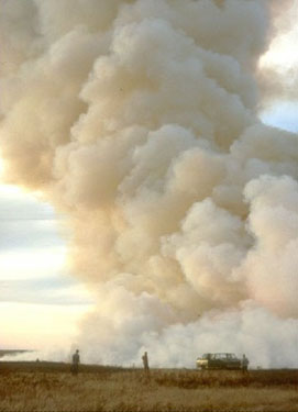
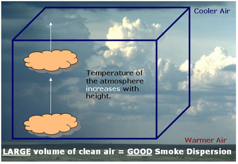
Figure 1. Good smoke dispersion
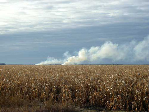
Figure 2. Poor smoke dispersion
How well smoke dispersion is on any given day is dependant on three factors:
- mechanical mixing
- convective mixing
- the volume of clean air available to mix the smoke ("dilution is the solution")
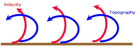
In the atmosphere, the wind acts like a giant spoon, mixing the smoke with clean air. Wind can carry smoke hundreds of metres up into the atmosphere. How well the wind mixes the smoke with clean air is dependent on the velocity of the wind and the underlying topography (there will be greater mixing in areas of uneven topography).
Wind can help to mix smoke with clean air on days when we have good dispersion or a large volume of clean air available with which to mix the smoke. However, on days when dispersion is poor or the volume of clean air is limited, wind will transport the smoke over great distances, resulting in more adverse effects from the smoke.
Convective Mixing
Although wind is a factor in smoke dispersion, it is not really a very effective mechanism by which to mix smoke with clean air. Convective mixing is by far the most dominant mixing force in the atmosphere.
To help explain convective mixing we can use the analogy of heating a pot of water on the stove. Usually when you boil a pot of water you simply put it on the stove and walk away; you do not have to stand there physically mixing the water. The water at the bottom of the pot will heat up first because it is closest to the heat source, the element. So how is it that the water at the top of the pot is also heated up?
As the water heats up, it becomes less dense than the water above it and rises to the top of the pot. The cooler, denser water on top sinks to the bottom. This results in what is called convection currents which carry the hot water from the bottom of the pot to the top and the cool water from the top to the bottom.
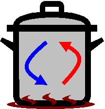
The redistribution of heat within the pot of water is called convective mixing. Even if we leave the pot alone, the water mixes itself because the temperature variations generate their own turbulence.
A similar process occurs on a daily basis in the atmosphere. The sun heats the ground and the ground in turn heats the air directly above it. This results in the temperature of the atmosphere decreasing with height. As the air near the ground heats up it begins to rise. This air will continue to rise as long as it is warmer than the surrounding air. As this warmer air rises, cooler air from above moves in (or sinks) to take its place near the ground. The greatest amount of convective mixing occurs during the warmest part of the day. On any given day, convective mixing can carry smoke from hundreds to thousands of metres into the atmosphere, which makes it a far more effective mixing mechanism than wind.
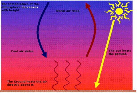
Smoke will continue to rise into the atmosphere as long as it is warmer than the surrounding air.
Day Versus Night Atmospheric Conditions
The concept of convective mixing should give you some indication of why burning is not permitted at night. Remember, convective mixing is the dominant force in the atmosphere mixing or diluting smoke with clean air. On any given day we want as much convective mixing as possible. Convective mixing is dependant on the sun heating the ground which in turn heats the air directly above it.
At night little to no convective mixing can occur because there is no heat source. Furthermore, the earth tends to cool more quickly than the atmosphere. Just as during the day the ground heats the air directly above it, at night the ground will cool the air directly above it. As a result, the temperature of the atmosphere tends to increase with height.
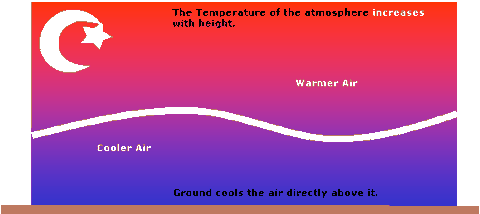
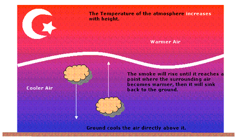
This results in what is called an inversion. An inversion is the result of warmer air lying overtop of cooler air. Inversions can be expected to form 90% of the time when the sun goes down.
How Does an Inversion Inhibit Smoke Dispersion?
Smoke will only rise as long as it is warmer than the surrounding air. At night a pocket of smoke will rise a bit, but as the air around it becomes warmer, it will actually sink back towards the ground and spread out horizontally.
This is what is called a diurnal (or daily) cycle, which basically repeats every day. During the day, we often experience what is termed unstable atmospheric conditions and at night we have much more stable atmospheric conditions.
Why is the Amount of Convective Mixing Not Constant From One Day to the Next?
There is one other factor that will affect how well smoke is mixed or diluted in the atmosphere on any given day. ‘Synoptic’ weather patterns affect how much clean air is available with which to mix the smoke. These weather patterns change from day to day and thus the volume of clean air available to mix with the smoke changes from day to day.
The Volume of Clean Air Available: the Effect of High and Low Pressure Systems
Convective mixing is capable of carrying smoke hundreds of thousands of metres into the atmosphere. On any given day, how high smoke is actually carried into the atmosphere is determined by the type of pressure system, high or low, that we are experiencing. Daily pressure systems dictate the volume of clean air that is available on any given day with which to mix the smoke.
The Influence of a High Pressure System
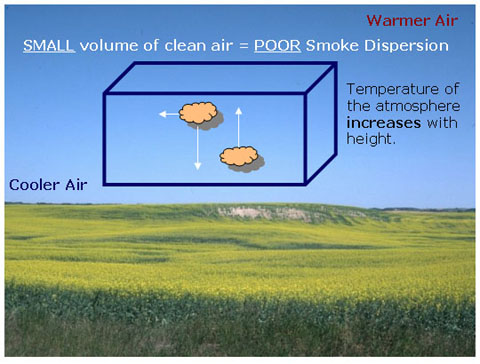
With a high pressure system you have a lot of air pressing down, or the air is subsiding. High pressure systems are often characterized by clear, blue skies and light winds. They are essentially very nice, calm days. Atmospheric conditions are very stable, meaning there is little to no activity in the atmosphere. On days like this the volume of clean air with which to mix the smoke is really quite small. Smoke may only rise a couple of hundred metres before it starts to spread out horizontally. When there is a lot of burning going on, this small volume of clean air can quickly become inundated with smoke and smoke dispersion will be minimal.
High pressure systems are usually indicative of a layer of warmer air over a layer of cool air. That is, the temperature of the atmosphere is increasing with height, which inhibits the smoke from rising very high into the atmosphere.
This is one of the most frustrating aspects of this program for producers. From a producer's point of view this would be considered a really good day for burning. There is little to no wind, so there is little chance of the fire getting out of control. From a smoke dispersion perspective, however, this is a very bad day for burning.
The clear skies and fair weather indicate that the atmosphere is very stable, that air is subsiding. On days like this, due to the enormous amount of pressure from the air pressing down, convective mixing is seriously limited. That is, air closer to the ground is unable to rise very high into the atmosphere.
The air closer to the ground is cooler than the air aloft. This is what is called a "capping inversion". This change in temperature ultimately acts like a lid or cap on the atmosphere, preventing smoke from rising very high into the atmosphere. This inversion is so strong that it actually inhibits convective mixing.
The Influence of a Low Pressure System
With a low pressure system, warm air is rising. Low pressure systems are usually characterized by cloudy skies (clouds tend to have a lot of vertical development), strong winds and rain. The atmosphere tends to be very unstable and there is a large volume of clean air available with which to mix the smoke. The temperature of the atmosphere decreases with height, which means that the smoke may rise thousands of metres into the atmosphere. On days like this, there is a lot of activity or mixing occurring in the atmosphere and smoke dispersion conditions tend to be very good.
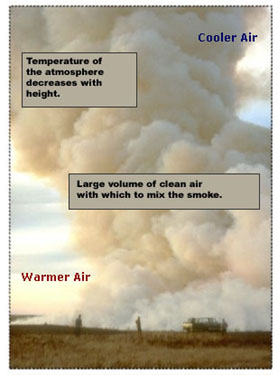
Above is a good example of what would happen to the smoke on a day with a low pressure system. As you can see there is smoke being generated from this one fire. However, because there is a lot of convective mixing occurring, the smoke is being lifted high up into the atmosphere. There is actually very little horizontal movement at all. There is a large volume of clean air with which to dilute or to mix the smoke. The temperature of the atmosphere is decreasing with height, which means that the smoke will continue to be carried high into the atmosphere (probably thousands of metres into the atmosphere). There is a very light wind to aid mixing.
When Does Most Burning Occur?
When it comes to burning of crop residue, the days that are the most suitable for the actual burning (clear, sunny, calm days) tend to be the worst for smoke dispersion. The best days for smoke dispersion are often those when weather conditions (windy, rainy) are such that burning cannot occur in a safe and controlled manner. As a result the majority of burning tends to occur on days when we are experiencing moderate smoke dispersion conditions. It is on such days that burning may be restricted to a certain portion of the day (usually later in the afternoon) or certain rural municipalities may be closed. We always have to be careful when we authorize burning on days when the smoke dispersion capabilities of the atmosphere may be limited. It is during those days that the atmosphere can become inundated with smoke if there is a substantial amount of burning taking place.