
Rearview
 Read Emma's Journal
Homesteading in Manitoba - Sections, Townships and Ranges
Central to the Dominion Government's plan to settle the West was the Dominion Land Survey. Land was divided into townships with thirty-six sections of 640 acres each and then into quarter sections. Even-numbered sections were reserved by the Dominion for free homestead grants. Sections 8 and 26 in every township were part of the lands awarded to the Hudson's Bay Company under the terms of the transfer of Rupert's Land. Sections 11 and 29 in every township were sold to raise money for schools. Other sections were reserved for grants to the railways. These grants were made as an incentive for, and aid towards, the construction of the Canadian Pacific and other railways. Provision was also made for reservation of town sites, marketplaces and churches.
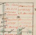
The Averills homesteaded the north-east quarter of section 36, in township 16, range 18 west of the prime meridian (NE36-16-18W). The names of individuals that received homestead and pre-emption rights were recorded in large ledgers called township general registers. They are organized by meridian and range, and within each range by township, section, and quarter section. They provide brief notes identifying provisional and final dispositions of land up to the date of the Land Patent awarded on the homesteader or purchaser's grant.
Land Patent awarded on the Averill's grant is also noted on a Dominion Lands Branch township plan. Township plans were inscribed with homestead and other entries, and annotated in red to show final land disposition. Every quarter section on each plan was inscribed with the number of the relevant homestead file, or the file number and name of homesteader or purchaser.
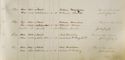 Township general register showing that a Land Patent was awarded on the Averill's grant in 1885. A of M, NR 0211, GR2133, Range18W, G 7208 |
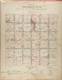 Township plan showing that a Land Patent was awarded on the Averill's grant in 1885. A of M, NR 0212, GR2404, Range 18W, G 10674 |
 Township plan showing that a Land Patent was awarded on the Averill's grant in 1885. A of M, NR 0212, GR2404, Range 18W, G 10674 |
Find out more search Emma Averill in the Keystone Archives Descriptive Database.