
Rearview
 Read Emma's Journal
Homesteading in Manitoba - Surveying the Land
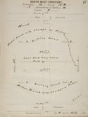
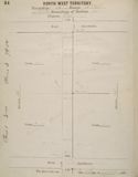
Beginning in 1870, the Dominion Government undertook an extensive survey of lands in the Canadian West in support of settlement activities. Dominion Land Surveyors were charged with the task of recording technical and descriptive data collected in the course of a particular survey in field notebooks. Often, the notebooks consisted of technical data such as azimuth, bearing, terrain, dwellings, fences and shorelines. Taken together with type and class of soil, and other descriptive data, the detailed reports produced by the Dominion Land Surveyors provided specific information about the characteristics and agricultural capabilities of individual townships and sections. As in most cases, the surveyor's report likely influenced the Averill's choice of location to settle. By 1880, there was a significant amount of surveying activity going on north of the Averill's homestead. Emma described their encounters with the Dominion Land Surveyors in her journal :
 Surveyor field notes for the Averill's quarter-section. A of M, NR 0157, GR 1601, Book #412, P17 |
 Surveyor field notes for the Averill's quarter-section. A of M, NR 0157, GR 1601, Book #412, P14 |
Find out more search Emma Averill in the Keystone Archives Descriptive Database.