West Interlake Watershed District |
 |
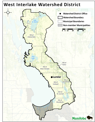
The West Interlake Watershed District is located along the eastern shores of Lake Manitoba and encompasses an area of approximately 6,950 square km. The member municipalities include Armstrong, Coldwell, Fisher, Grahamdale, St. Laurent, West Interlake, and Woodlands.
The previous name of the West Interlake Watershed District was the West Interlake Conservation District, which was established in 2008. On January 1, 2020, through proclamation of the Watershed Districts Act, all of Manitoba’s 18 conservation districts transitioned to 14 new watershed districts, with boundaries based on watersheds.
The district completed the Southwest Interlake Integrated Watershed Management Plan in 2018 and is currently implementing the plan through a variety of programs and activities. The district offers the following programs: groundwater protection (sealing abandoned wells, well water testing), riparian area management (fencing, off-site watering systems), aquatic habitat restoration and enhancement (in-stream structures), wildlife habitat protection, surface water quality protection (nutrient management, fuel tank rebate), permanent cover (forage seed assistance, cover crop seed mixes, sod seeding), tree planting (seedling sales), and environmental education (water festival, in-class presentations).
Box 732, 9 Main Street
Lundar, Manitoba, R0C 1Y0
204.762.5850 (P)
204.762.5862 (F)
https://wiwd.ca
contact@wiwd.ca


