
Manitoba Spring Road Restrictions (SRR) Program
Five Climate Zones
Due to differing thawing rates, the province has been divided into five climate zones for the purposes of implementing the SRR (the start and/or end dates in the five climate zones may be different):
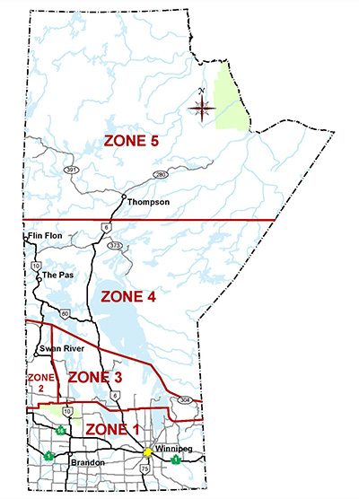
Zone 1
Means the Province of Manitoba south of the line that includes PR 264, going easterly to the west boundary of Riding Mountain National Park (RMNP), going north and then east along the RMNP boundary, continuing easterly to include PR 582 and PR 278, going south-easterly and then easterly to include PR 418, continuing easterly to the east shore of Lake Winnipeg to include PR 512, PTH 17, PTH 7 and PR 222, then going southerly following the eastern shore of Lake Winnipeg to the north shore of the Winnipeg River, going easterly along the north shore of the Winnipeg River to include PTH 11, and going easterly to the Ontario boundary.
Zone 2
Means the Province of Manitoba south of the line that includes PTH 77, going south-easterly to include PR 483 (Pelican Rapids) and then going southerly to Cowan and south-easterly to Ethelbert to include PTH 10 and PR 367, going southerly to the RMNP boundary, going westerly and then southerly along the RMNP (Zone 1) boundary, and going westerly along Zone 1 boundary to the Saskatchewan boundary to include PR 482 and PR 549 (Shellmouth).
Zone 3
Means the Province of Manitoba east of Zone 2 and north of Zone 1, and south of the line that includes PR 272 (Duck Bay), going south-easterly to include PR 513 (Dauphin River), PR 412 and PR 234, and continuing south-easterly to Ontario boundary to include Calders Dock, Hollow Water and Bissett.
Zone 4
Means the Province of Manitoba north of Zone 2 and Zone 3, and south of the line that includes Sherridon Road (Sherridon), going easterly to include PR 393, Wabowden Access Road (Wabowden) and Sipiwesk Lake Access Road, and easterly to the Ontario boundary.
Zone 5
Means the Province of Manitoba north of Zone 4.
To see roadway detail, please visit the official Manitoba Highway Map. Note that spring road restrictions are not defined on that map. For detail on the spring road restrictions, please visit the Spring Road Restrictions Order, SRR Maps or Summary of Changes.