Header Side Menu Content Footer Search
Printer Friendly Site Map Contact Government
Government of Manitoba
  • Resident and online services
    • Search Programs and Services
    • Forms
    • Publications
    • Finding Work
    • Lost Identification
    • Moving to or Around Manitoba
    • Communities around Manitoba
    • Maps
    • Online Services
    • Social Media Directory
    • Mobile Applications
  • Business
    • Search for Business Information
    • Starting a Business
    • Business Research
    • Financing a Business
    • Registration, Legal and Licencing
    • Doing Business with Government
    • BizPaL
  • Government
    • Premier
    • Cabinet Ministers
    • Departments
    • Agencies, Boards and Commissions
    • Proactive Disclosure
    • Legislative Assembly
    • Manitoba Courts
    • Manitoba Laws
  • Visitors
    • Things to do
    • Places to Go
    • Where to Stay
    • Events
    • Trip Essentials
    • Visitor Information Center

Business, Mining, Trade and Job Creation

manitoba.ca > Business, Mining, Trade and Job Creation > Resource Development

Geoscience

Digital Elevation Model of Manitoba


Ross River Pluton image #4

  • Ross River Pluton Introduction and image #1
  • Ross River Pluton image #2
  • Ross River Pluton image #3

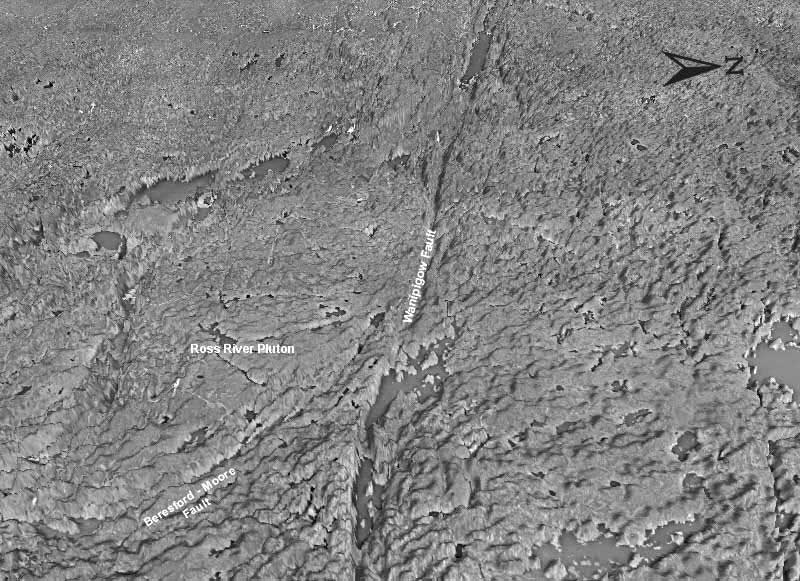
DOI draped DEM, 1.5x VE, Oblique View
For a large view of this image


Ross River Pluton Map#4

Back to Ross River Introduction & Image #1

Back to DEM index

back to top

Get Started
  • Business, Mining, Trade and Job Creation
  • Resource Development Home
  • About Us
  • Manitoba's Mineral Industry
  • Manitoba Exploration Resources
  • Mines (Regulatory)
  • Geoscience
    • GIS Map Gallery
    • Overview of Manitoba Geology
    • Surficial Geology
    • Mineral Commodities in Manitoba
    • Industrial Minerals
    • Lithium in Manitoba
    • Rare Metals in Manitoba
    • Diamonds in Manitoba
    • Digital Elevation Model (DEM) of Manitoba
      • Introduction
      • Acknowledgments
      • DEM Data Index
      • Metadata Text
      • Digital Ortho Image Specifications
      • Large DEM Map of Manitoba
      • Downloads/Ordering
      • Duck Mountain
      • Hodgson Plain
      • Ross River
      • Assiniboine Spillway
      • Darlingford Moraine
      • Gunton Escarpment
      • Sandilands Moraine
      • Pas Moraine
      • Red River Valley
    • 3-D Geological Mapping in Manitoba
    • Platinum-group Elements in Manitoba
    • Phanerozoic Geology
    • Paleofloods in the Red River Basin
    • Geological Survey Activity Tracker
    • Report of Activities
    • Geological Databases
    • Publication Downloads
    • Manitoba Drillcore Libraries
    • Williston Basin TGI
    • Manitoba Geological Survey Technical Posters
    • Winnipeg GAC-MAC Fieldtrip Guidebooks (1996 and 2013)
    • Manitoba Geological Survey Short Course Presentations
    • Related Geology Links
  • Resources and Publications
  • Boards and Commissions
  • Mineral Education / Manitoba Rocks!
  • Regulatory Services/Oil and Gas
Stay Connected
  • Join us on Facebook
  • Follow us on Twitter
  • Subscribe to our RSS
  • View our videos on YouTube
  • View our photos on Flickr
Close Window
manitoba.ca | 1-866-MANITOBA
  • Accessibility
  • Disclaimer
  • Copyright
  • Privacy
  • Twitter
  • Facebook
  • YouTube
  • Flickr
Government of Manitoba