
Eastern Parks
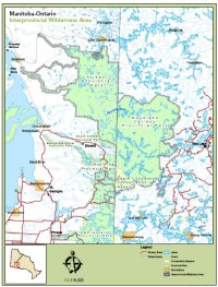
Manitoba-Ontario Interprovincial Wilderness Area
Recognizing the value and
ecological importance of the boreal forest, the Ontario Ministry
of Natural Resources and Manitoba Conservation have established
a Manitoba-Ontario Interprovincial Wilderness Area. This
wilderness area, which lies along provincial borders, encompasses
over 9,400 square kilometres and includes Woodland
Caribou Provincial Park and
the Eagle-Snowshoe Conservation Reserve in Ontario, and Atikaki
Provincial Park and
parts of Nopiming
Provincial Park in
Manitoba.
| By managing this cluster of parks and wilderness as one land area, conservation of an integral part of Canada’s central boreal forest will be strengthened for future generations. Manitoba and Ontario are committed to working together to conserve the national and international ecological integrity of this boreal forest by co-ordinating resource management, encouraging research, co-ordinating marketing and developing recreational opportunities. |
Wilderness Area Information
News Release, July 30, 2008 – Manitoba and Ontario Establish Canada’s First Interprovincial Wilderness Area
Summary of Manitoba-Ontario Interprovincial Wilderness Area
Memorandum of Understanding Respecting the Manitoba-Ontario Interprovincial Wilderness Area
Map of Manitoba-Ontario Interprovincial Wilderness Area
Located in the heart of Canada’s Precambrian Shield, this wilderness area features outstanding examples of boreal forest. This forest represents critical summer and winter habitat for a segment of Canada’s woodland caribou population.
The area is a high quality wilderness recreation area. It contains many world-class canoe routes including the Bloodvein, Pigeon and Bird Rivers, and provides many angling and wildlife watching opportunities.
Where to stay
Lodges, outpost camps and tenting are the only forms of accommodation in the area. For most visitors, this is a true wilderness experience. There are no developed campsites, with the exception of campsites north of Tulabi and Seagrim Lakes. Camping fees are only applicable in Ontario. Visitors must practice no trace camping out of consideration for the land. Please visit individual park websites for additional details.
Area Directions
Road access is available only to the perimeter of the area. In Manitoba, from Winnipeg, follow PTH 59 north to PTH 44, east to PTH 11, north to PR 313, east to PR 315 leading to Tulabi Lake at the south end of the park. PR 314, just inside the park, takes you north through the park (227 km from Winnipeg).
In Ontario, from the TransCanada take Hwy 105 north to Red Lake. From Red Lake you are able to access the area at four locations. Take Hwy 618 north of Red Lake to the Nungesser Road, north to the Pineridge Forest Access Road west to the Lund Lake access area (distance 80 km). West from Red Lake take Hwy 604 to the Suffel Lake Forest Access Road to the other three access areas: Johnson Lake (33 km), Onnie Lake (45 km) and Leano Lake (72 km).
Authorized air access is permitted in specific locations. Check with the individual parks for regulations regarding air access. Flight arrangements can be made with lodges, outfitters, or air charter companies.
To explore the heart of this area, one must travel by water. In Manitoba the most popular water route begins at Wallace Lake, south of the Atikaki Provincial Park. Wallace Lake is 250 km. from Winnipeg via PTH 59, north to PR 304. In Ontario approximately 2000 km of canoe routes in the interior is accessed by road or by charter aircraft.
Contact Information
Manitoba Parks and Protected Spaces
Tel: 204-945-6784
Toll Free 1-800-214-6497
Email: mgi@gov.mb.ca
http://www.manitobaparks.com
Ministry of Natural Resources - Ontario Parks
Tel: 807-475-1497
http://www.ontarioparks.com/