
|
The Manitoba Drought Management Strategy provides a framework for an integrated approach to managing drought, with the goal of minimizing the environmental, social and economic impacts of drought on Manitoba’s residents, economy and environmental resources. The Manitoba Drought Management Strategy provides a history and overview of drought on the Canadian Prairies, defines science-based indicators to characterize drought conditions, and outlines strategies to improve communication, coordination, and response to drought and increase Manitoba’s drought preparedness. Please refer to the strategy for more details. |
 Drought Management Strategy (pdf) |
Manitoba Drought Monitor
The information below highlights the drought management efforts currently underway in Manitoba. The Manitoba Drought Management Strategy provides an overarching framework and action strategies for an integrated approach to minimize the impacts of impacts of drought. Up to date information on water availability and drought conditions is accessible below, while our suite of drought indicators can be viewed interactively on the Drought Indicator Map.
If you are being impacted by drought conditions and require assistance, up to date information on current drought resources and programming is under the Resources & Programming tab below. Within the Resources & Programming information you can also find information on how you can make every drop count through conservation and efficient water use.
For additional information, contact drought@gov.mb.ca to be connected to resources and support from across government.
Manitoba Drought Management Strategy
Drought Condition Reports
Water availability and drought conditions reports are provided regularly through the open water season. Please see below to access the most recent and historical reports.
Drought Indicator Map
View a full-screen version of the map
All drought conditions maps will be updated regularly throughout the open water season. During the winter months, only the Canadian and U.S. Drought Monitor map will continue to be updated on a monthly basis.
Drought Impacts
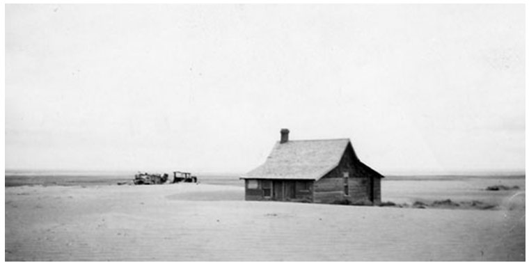
Drifted soil near Cadillac, Saskatchewan, 1937
1988 drought, near Pipestone (TWP 6-RGE 26), Manitoba, June, 1988 (Courtesy: Agriculture and Agri-food Canada).
Spilt Lake, Nelson River Basin, June, 2003 (Courtesy: Manitoba Hydro).
Canadian wildfires produce river of smoke, June 29th, 2015.
(Image from NASA Earth Observatory: https://earthobservatory.nasa.gov/IOTD/view.php?id=86151)
History of drought on the Canadian Prairies
In the last 100 years, geographically extensive, multi-year droughts with severe impacts were observed in the 1930s, 1960s, 1980s, and most recently in the early 2000s. In fact, according to the Institute for Catastrophic Loss Reduction's Canadians at Risk report (2010)1, droughts are responsible for five out of the top ten most expensive Canadian natural disasters on record.
1 Institute for Catastrophic Loss Reduction (ICLR). 2010. Canadians at Risk: Our exposure to natural hazards.
Drought in the 1800s
Although not as well documented as the droughts of the 1900s, there were also many severe droughts that occurred in the 1800s. The Institute for Catastrophic Loss Reduction (Institute for Catastrophic Loss Reduction, 2010)1 lists impacts such as scorched potato crops in the Red River Valley in 1805, continuous drought and hordes of grasshoppers across the prairies from 1816 to 1819, complete failure on the 1846 crop in the Red River Valley, crop failures and grasshopper plague in 1868, and nine years of continuous drought across the prairies in the 1890s.
1 Institute for Catastrophic Loss Reduction (ICLR). 2010. Canadians at Risk: Our exposure to natural hazards.
1930s Drought - The Dirty Thirties
Although droughts in the latter half of the 19th century may have been more severe in some areas, the drought of the 1930s was the drought with the largest impact on Manitoba and the Canadian Prairies. The drought set in during 1929 and prevailed through to the early 1940s. The drought of the 1930s was made famous by massive dust storms which earned the decade the nickname "the dirty thirties". The multi-year severe drought, combined with the 1929 stock market crash, led to devastating socioeconomic conditions on the prairies. Blowing dust and significantly reduced crop production occurred from the early 1930s to 1939. By the mid-1930s the drought was set in across the North American prairies, including across the Canadian Prairies and south all the way to Texas in the U.S.A. Poor soil conservation and farming practices contributed to the soil conditions that allowed the dust storms to reach extraordinary proportions. Crop disease and grasshopper infestations added to the agricultural devastation. With low prices for cattle and lack of feed, conditions forced producers to reduce cattle herds by selling at low prices, or in some cases, culling portions of their herd with no return. The 1936 census indicates that 500 farms were abandoned in Manitoba (Dean et al., 1998)2. Lack of social programs and crop insurance combined with the poor economic conditions exacerbated many socioeconomic drought impacts. The dust and lack of water also caused health impacts on people, livestock, and wildlife. "Dust pneumonia" and other respiratory illnesses caused many deaths. Failed crops and economic instability of farming operations created severe mental stress for farming families which led to increased suicide rates. Drought conditions finally began to ease in the early 1940s. The Prairie Farm Rehabilitation Administration (PFRA) was established in 1935 by the Federal Government of Canada as a Branch of Agriculture and Agri-food Canada. PFRA's mandate was to mitigate and recover from the drought by delivering various programs on soil erosion and on-farm water supply to support famers and agricultural industries.
Drifted soil near Cadillac, Saskatchewan, 1937
2 Dean, William G.; Conrad Heidenreich; and Thomas McIlwraith. 1998. Concise Historical Atlas of Canada. University of Toronto Press.
Early 1960s Drought
The drought of the early 1960s was not as long in duration as the drought of the 1930s but was one of the most severe droughts on record. In June 1961 there were record low rainfall accumulations coinciding with record mean monthly temperature and bright sunshine hours. Conditions led to wide scale crop failures and famers selling off cattle due to lack of feed and water. Drought conditions in many locations were worse than conditions in the 1930s. Dust storms were prevalent reminding people of the great dust bowl of the 1930s. Although moderate droughts were reported throughout the 1960s, widespread severe drought was limited to 1961.
Drought of the late 1980s
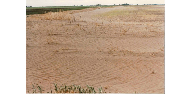
The return of widespread severe drought occurred in the 1980s. The drought had significant economic impacts in Manitoba. The drought peaked in severity in 1988 causing agricultural production in Manitoba to reduce to 60% of average. There was also an $80 million dollar loss in hydro power exports in 1989 (Simard and Joyce, 2005)3. Loss of wetland habitat and increase incidence of disease had a negative impact on waterfowl populations and associated recreation opportunities. Despite the severity of impacts, conditions could have been worse if drought preparedness had not been improved since the 1930s. Lessons on soil conservation had been learned from the 1930s and measures such as new tillage techniques, and treed shelter belts greatly reduced the potential for wind erosion of soils. Crop insurance and government subsidies were helpful to reduce socioeconomic impacts.
1988 drought, near Pipestone (TWP 6-RGE 26), Manitoba, June, 1988 (Courtesy: Agriculture and Agri-food Canada).
3 Simard, T.J., and J. R. Joyce. 2005. Manitoba Hydro: 2002-2004 Drought Risk Management Review.
(https://www.hydro.mb.ca/regulatory_affairs/electric/gra_08_09/information_requests/Appendix_43-Report_on_2002-2004_Drought.pdf).
Drought from 1999 to 2004
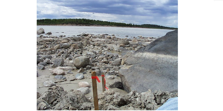
The drought that occurred from 1999 to the mid-2000s was a severe multiyear drought that covered a large portion of the Canadian Prairies. It is the drought of record in some areas of Alberta. The drought had impacts across the prairies on agriculture, tourism, health, hydro power generation, and forestry. The Canadian gross domestic product lost $5.8 billion dollars for 2001 and 2002 due to the drought and more than 41,000 jobs were lost (Lawford et al., 2008)4. There was a $3.6 billion dollar reduction in agricultural production in the 2001/2002 fiscal year (Lawford et al., 2008)4. The drought also led to a dramatic increase in forest fires and numerous massive dust storms were reported. In fiscal year 2003/04, Manitoba Hydro incurred the largest financial loss in its history of $436 million due to reduced flow in its system (Manitoba Hydro-Electric Board, 2004)5.
Spilt Lake, Nelson River Basin, June, 2003 (Courtesy: Manitoba Hydro).
4 Lawford, Rick, Harvey Hill, Elaine Wheaton, Irene Hanuta, Alf Warkentin and Bill Girling. 2008. User Expectations for the Drought Research Initiative (DRI).
Canadian Meteorological and Oceanographic Society Bulletin. Vol. 36, No 3.
5 Manitoba Hydro-Electric Board. 2004. Manitoba Hydro-Electric Board 53rd Annual Report.
Recent Droughts
Drought conditions quickly developed across Manitoba in 2012 after widespread flooding that occurred in 2011. Although short in duration, drought impacts were already noticeable as pasture productivity was reduced and many dugout supplies were inadequate for livestock operations. Wildfires broke out in May near the communities of Badger and Vita leading to the declaration of local states of emergency. In October more wildfires occurred in southeast Manitoba and the Interlake. In the October fires two states of local emergency were declared, approximately 270 people were evacuated including the communities of Vita and Ross, and 14 homes or farm operations were damaged.
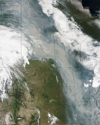
In 2015 drought conditions, warm temperatures and increased winds resulted in extreme wildland fire risk across western Canada. The number of fires per day significantly increased by the end of June, and the fire situation continued to escalate through most of July. Saskatchewan incurred the largest burned area, followed by the Northwest Territories and Alberta. Thousands were forced to evacuate their homes, and the number of Canadian agencies impacted by wildland fire activity during this period resulted in unprecedented international aid and mutual aid cooperation (CIFFC, 2015)6. In Manitoba, northwesterly winds blanketed large regions of the province with thick smoke, reducing visibility and air quality. This reduction in air quality placed residents, particularly children, seniors, pregnant women, and people with heart or lung conditions, at increased risk of health issues from breathing in smoky air.
In 2016, a major wildland fire impacted Fort McMurray and surrounding communities, evacuating 88,000 people and burning 2,400 buildings. This event was Canada's fourth largest fire on record, and became the most expensive natural disaster in Canadian history (NRC, 2017)7.
2017 brought moderate drought conditions to Manitoba after an early spring freshet resulted in above normal streamflow conditions across most of southern and northern Manitoba. However, after months of below average precipitation during the growing season, by July and into August almost all of Manitoba was experiencing moderate to severe precipitation conditions. Due to warm temperatures, dry conditions and high winds, August brought a significant increase in wildfire activity relative to previous months, resulting in serval fires causing the evacuation of thousands of residents from numerous northern communities. Although the drought conditions experienced over the 2017 growing season generally did not have an unfavourable impact to crop yields, there was a reduction in pasture productivity and concerns about on-farm water supplies going into the winter season.
Canadian wildfires produce river of smoke, June 29th, 2015.
(Image from NASA Earth Observatory: https://earthobservatory.nasa.gov/IOTD/view.php?id=86151)
6CIFFC: Canadian Interagency Forest Fire Centre. 2015. Canada Report 2015
7NRC: Natural Resources Canada. 2017. Infographic: Fort McMurray fire at a glance
Historic Drought
Tree ring analysis provides insight about the climate on the prairies prior to human observations started in the early 19th century. Tree rings research provides data that demonstrate the occurrence of wet and dry cycles in prairie rivers for the last 1000 years. A clear multidecadal cycle between wet and dry cycles exists. Tree rings in the Upper Assiniboine River Watershed provide evidence that the most severe drought on record occurred in the latter half of the 16th century. This drought appears more severe, and much longer, than the drought of the 1930s. Tree rings form the Red River Basin show that the Red River was also in a severe multi-decade drought in the mid- to late-1500s. It is difficult to comprehend the catastrophe that would occur if Manitoba and the rest of the Canadian Prairies were to experience such a severe, multi-decade drought today. It would be the greatest natural disaster the Canadian Prairies has ever experienced.
Future Drought
The history of drought in Manitoba and the rest of the Canadian Prairies demonstrates that the impacts of drought can be extreme and can have consequences from a local to national scale. The historical cycle of wet and dry periods assures that the return of severe drought to Manitoba and the Canadian Prairies is inevitable in the coming decades. Severe multiyear droughts have occurred frequently in each century for the last number of centuries.
The droughts throughout the 20th century have proved that increased capacity (preparedness) through a variety of methods can help reduce the impacts of drought. The best way to protect Manitoba from the harsh impacts of drought is to prepare as best as possible before severe drought occurs. Manitoba Drought Management Strategy will enhance Manitoba's understanding of drought and as action items are implemented, increase Manitoba's resilience to drought.
Have you seen drought impacts on your area? Let us know! Please send us an email at drought@gov.mb.ca. Don't forget to include pictures!
Resources & Programming
Resources
Conservation and Efficient Water Use (NEW)
- Find information on how you can Save Water and make every drop count through conservation and efficient water use.
Agriculture
- Agriculture and Agri-Food Canada, Drought Watch
- Manitoba Crop and Livestock Management in Dry Conditions
- Manitoba Agriculture, Weather Program - Conditions and Reports
- Manitoba Crop Reports
- Manitoba Hay Listings
- Manitoba Agricultural Services Corporation (MASC)
- Manitoba Agri-Maps
Drought
Groundwater
- Manitoba Water Well App
- The Water Branch can provide information on your current well if available, and what the expectations might be for constructing a new well. Email your contact information, the legal land location and the information you are looking for (existing well information or groundwater potential) to Manitoba Groundwater: Drought. Feedback provided may include aquifer depths, potential pumping rate, and if available the water quality in the area. A listing of Licensed Well Drilling Contractors is also available.
Other
- A Made-in-Manitoba Climate and Green Plan
- Government of Canada Historical Climate Data
- Manitoba Wildfire Program
Contacts
Contact Us
Have you seen drought impacts on your area? Let us know. Don't forget to include pictures, if available.
Mail:
Water Science & Watershed Management Branch
14 Fultz Boulevard, Box 14
Winnipeg, MB
R3Y 0L6
Email:
Drought@gov.mb.ca